Kandahar, Second Largest City Of Afghanistan
 The mention of Afghanistan’s second-largest city conjures up a collage of terrorist training camps, rugged terrain, warlords, narcotics, fierce tribes and the War on Terror. Its strategic and political importance is understood by the Pashtun proverb: ‘Control Kandahar and you’ll control Afghanistan’. This was a lesson that Alexander the Great, Genghis Khan and even the Russians failed to learn. Unfortunately since the fall of the Taliban in 2001, the security situation in the city and surrounding areas has deteriorated significantly to the point where there was an average of one suicide bombing a week in 2006. Although the current players, Afghan and international, understand the significance of controlling Kandahar this Holy Grail continues to elude them.
 Despite the violence surrounding them the Kandaharis continue their daily lives, albeit lived with restrictions and a level of fear. Women continue to be the most affected – few women are seen in public on the streets of Kandahar and if ever you do see one the majority will be wearing the nylon burqa. Life for the women of Kandahar is invariably lived behind the high walls of their family compounds with few girls being given permission to attend school still, despite reports in the media extolling the liberation of girls since the arrival of democracy.
 Older Kandaharis will tell you about the times before the Russian invasion, when they hosted hippies taking the overland trail in the guesthouses that lined the streets around Chowk-e Shaheedan. Although it may be some time before Kandahar is ready for independent travellers again, it is clear that the NGO, international organisation and contractor communities are desperately needed to improve the lives of Kandaharis. Although millions of aid dollars have been spent in the area, insecurity and corruption have prevented it reaching many people.
In years to come there is no doubt that travellers will enjoy views over Kandahar from the Forty Steps, Pashtun hospitality at picnics in the Arghandab Valley and visits to the Mosque of the Sacred Cloak.
Altai Tavan Bogd National Park Of Mongolia
Located south of Mongolia’s highest mountain, this national park covers an area of 6,000 sq km and is home to three lakes and a glacier.

A stunning landscape of high glaciated snow capped mountains, alpine and sup-alpine forests, large lakes, rivers and streams, mountain grasslands, barren rocky mountain ranges and semi-arid desert type valleys. A very rugged land. In the park region there would be snow until end of May. Rainy season is from mid of july to Mid of August. Average temperature in Summer: Day: 16-25°C, Night: 7-13°C
From Ulgii center to ATB National Park is 180 km. There are no bus or taxi services from Ulgii center, where the National Park Headquarters are, to the park itself. You will have to find your own way there by hiring a car (russian jeep or microbus) and driver. You can ask at the park information center in Ulgii to help arrange a car and driver for you. They will know the current daily rate. Alternatively, the local Ulgii hotels and tour companies can also help. It is up to you to make sure the car and driver are safe, ie: good running condition, tires, spares, water, first aid kit, etc and that the driver doesn’t drink! There are good drivers and bad drivers.
Park permit is required to enter the ATB National Park. Buy an ATB National Park permit from ATB National Park Administration office in Ulgii center. Your tour company will take care of this for you, or you can ask at the national park information office for someone to help arrange this for you if traveling independently.
 Lots to do in the park. High alpine and very serious climbing, backcountry skiing (may spring skiing is great!), fishing, great mountain trekking, horse and camel trekking, whitewater kayak and rafting, and learning about and experiencing the unique khazakh culture of the area. make sure to buy a good map of the area before you go. You can get topo maps and travel maps at the “Map Shop” in Ulaanbaatar. The Visitor Information Centre in the main post office just off (west) of Sukhbaatar Square in Ulaanbaatar can direct you to this. Again, no restaurants in the park. Bring bottled or boiled water with you and the means to purify or boil water when camping and traveling. Lots of water around, just take the usual precautions. When with the locals, there’s always vodka!
Most of the tour companies who travel in the park will bring you to their own pre-arranged accommodation, either their own lodge or camp set up. There are a few very scattered ger (yurt) camps around, but you’ll have to check with the park office for their current locations.
Inside the park, there are no commercial lodges, hotels, backpackers, etc. Independent travelers can find lodging with local Khazakh herders if they want to get a very enjoyable and interesting local experience. If you do this, pay them for your stay. Income opportunties for these people are very limited. Two to four dollars a night is currently acceptable and good value for the experience. When traveling further into the mountains, there is no lodging unless you carry a tent, and this is recommended.
There are now several herder communities who have gotten together and can provide some primitive services such as accommodation and guiding. Check with the park information office to find where these are if you want to visit a real community based tourist venture. It can be a great experience, but be prepared for basic, very basic.
 If traveling with a tour company they will (or should) have everything you need for a comfortable camping experience. Take pains to make sure they are reputable and do have what you need. Ask the park information office about good camping areas in the park.
There are very few designated camping sites around the park, so it’s basically up to you where you want to put your bones for the night. If around a herder family, it’s a good idea to ask if you can camp closer to their ger (yurt). Most will enjoy having you there and you will be secure for the night.
Did you know? That the park permit costs 3000 tugrik (Approx. $2.4 ). If you are going into the park, which is next to the border with Russia and China, you will also need a border permit obtained from the border guards office in Ulgii center. Not having one can potentially get you arrested.
Yangtze River Of China
Are you eager to discover the vast land of China? Originating from Tangula Mountain Range in Qinghai Province, the Yangtze River is the largest and the longest river in China! Because of this, a Yangtze River cruise can offer the perfect way to discover the amazing culture and history of China while enjoying the benefits of cruising as well.
 Originating from Tangula Mountain Range in Qinghai Province, the Yangtze River is the largest and the longest river in China! Because of this, a Yangtze River cruise can offer the perfect way to discover the amazing culture and history of China while enjoying the benefits of cruising as well.
While you enjoy the picturesque scenery alongside the Yangtze River, you can also visit historic sites ashore such as the Ghost City in Fengdu, the Precious Stone Stronghold in Zhongxian, or the White Emperor City in Fengjie. In addition, you are sure to be impressed by the two famous water conservancy projects in China: the Three Gorges Dam Project and the Gezhouba Water Conservancy Project.
Having a history of nearly 2,000 years, Fengdu County has formed a special culture of ghosts and the afterlife. Well known as the resting place of the spirit of the dead, Fengdu is the most characteristic historic and cultural town in China. Zhongxian is another county filled with cultural relics. Considered to be one of the world’s top architectural buildings, Shibaozhai (Precious Stone Fortress) is situated in Zhongxian.  Numerous tourists have visited this spot and marveled at its unique architecture style. Like Fengdu and Zhongxian, Fengjie is a county with a dense history…people have been living here since the16th century BC! Fengjie County is home to the magnificent Baidi City (White Emperor City). One can also view historic relics such as the Tuogu Tang (Entrusting Son’s Hall) and Guanxing Ting (Observing Stars Pavilion) while visiting this area and its natural beauty drew a great number of notable poets, who eulogized the area in their poems.
 Numerous tourists have visited this spot and marveled at its unique architecture style. Like Fengdu and Zhongxian, Fengjie is a county with a dense history…people have been living here since the16th century BC! Fengjie County is home to the magnificent Baidi City (White Emperor City). One can also view historic relics such as the Tuogu Tang (Entrusting Son’s Hall) and Guanxing Ting (Observing Stars Pavilion) while visiting this area and its natural beauty drew a great number of notable poets, who eulogized the area in their poems.
The Three Gorges Dam on the Yangtze River, the largest dam of its kind in the world, will provide China with tremendous power generation and flood control services. Expected to take 17 years to construct, the project got the go ahead from Chinese Government in 1992, some seventy years after Dr. Sun Yet-Sen, pioneer of the Chinese democratic revolution, first proposed the idea. The Gezhouba Water Conservancy Project, the experimental dam of the Three Gorges Dam Project, is located in Yichang City of Hubei Province.
Cruising on the Yangtze River can be a once in a lifetime experience!  Whether you choose to cruise upstream or downstream, the route is a combination of natural beauty and historic relics. A Yangtze River Cruise will take you through the cradle of Chinese culture, while giving you the opportunity to see some of the most spectacular scenery imaginable. Winding through the heart of China, tourists will experience both historical and natural wonders!
 Whether you choose to cruise upstream or downstream, the route is a combination of natural beauty and historic relics. A Yangtze River Cruise will take you through the cradle of Chinese culture, while giving you the opportunity to see some of the most spectacular scenery imaginable. Winding through the heart of China, tourists will experience both historical and natural wonders!
Did you know? That at 2,606 meters (1.6 miles) long and 53 meters (173 feet) high, the dam consists of two hydro electric power stations, three navigation locks, and several sluice-gates some of which are used for accumulating water in dry seasons. At the first sight of this giant project, visitors will surely be astonished at its size as well as the majestic waterfall pouring from its water gates.
Wild Wadi Waterpark Of United Arab Emirates
 Wild Wadi Waterpark is one of the most exciting family attractions of UAE. It comprises of over twelve hectares of incredible Wild and Wet fun. The location of the theme park is less than a half hour drive from the heart of the city.
The theme park comes with twenty four heart-racing, modern slides, rides and other attractions ideal to suite all ages. An admission will include rubber tube, life jackets, body boards and the full entry wherein you can ride all the rides available out there. When it comes to security of your children, don’t worry, because they have provided over a hundred of lifeguards on duty to guide you and your children, so you can relax and enjoy yourself without worrying your kids.

Wild Wadi features the Wave Park where a double-point wave break is tackled by some of the finest visitors and surfers. The Wave Park itself includes a number of great features like the Wave House Durban South Africa boarders who show off their vibrant style and very unique tricks and techniques.
The most popular ride is the Jumeirah Sceirah. Fly down 355 meters of water slide at up to 80 kilometers per hour. Crash down the 1800ft rush down Ravine for white knuckle  spills and chills or head to the center of the park for the most excellent panoramic views of the area while hunkering down on your own sun bed and catching some rays, making it as one of the best tourist destinations in UAE. Truly a one of the most remarkable place in United Arab Emirates.
 spills and chills or head to the center of the park for the most excellent panoramic views of the area while hunkering down on your own sun bed and catching some rays, making it as one of the best tourist destinations in UAE. Truly a one of the most remarkable place in United Arab Emirates.
Did you know? That the name “wadi” means a type of riverbed or valley that fills with water when rainfalls are heavy.
Ferris Wheel of Singapore “Singapore Flyer”
 Singapore Flyer is one of the best tourist attractions of the entire country. It offers a breathtaking panorama of the shimmering marina Bay waterfront and Historical Landmarks.
There are many reasons why you should try to ride the Flyer when you visit Singapore. One of that is, Singapore Flyer is considered as the biggest and largest observation wheel in the world standing of about 170m with a height of 42-storey building and is 30 meters taller than the famed London Eye. Another reason is at every turns, you’ll be stunned by the view it provides “360°” facing most of the landmarks and historical places nearby like Singapore River, Marina Bay, Merlion Park, Marina Sands, Raffles Place, Esplanade-theatres on the bay, circuit F1, Empress Place, Fort Canning Park and the Padang and many many more.
 When it comes to food, Singapore Flyer offers numerous dining establishments where you can find most of the local favourites and foreign dishes as we. The Flyer also comes with souvenir shops from the most expensive to cheapest one.
Consider visiting the Sentosa Island which happens to be the “Top Tourist Destination” of the country. From there, you’ll find the Integrated Resort from hotels to Casinos. There are many more destinations to include. You may find the cheapest gadgets at Sim Lim Square, cheapest souvenirs at Bugis Street, cheapest shops at China Town and some valuable experience at Little India.
Did you know? That the total cost of building the flyer wheel is about S$240 million dollar, a one-of-a-kind experience you wouldn’t want to miss. The Flyer is the Largest Observation Wheel in the world and is considered as one of the best tourist destinations of Singapore.
Bohol “Tarsier and Chocolate Hills” of the Philippines
Bohol of the Philippines is very fast becoming one of the top travel destinations in Asia.
Bohol offers a wide variety of attractions from natural white sand beaches, old houses, diving sites, scenic natural  sights, ancient churches, historical sites and even beautiful ecotourism highlights, birding, dolphin and whale watching and of course diving are popular activities of the place. Bohol’s natural heritage and ecology is one of the best things to see.
 sights, ancient churches, historical sites and even beautiful ecotourism highlights, birding, dolphin and whale watching and of course diving are popular activities of the place. Bohol’s natural heritage and ecology is one of the best things to see.
Most of the 47 towns of Bohol have old massive stone churches with frescoes, all are done under the Spanish colonization. Bohol is also replete with ancestral homes, heritage sites, and some of the best conserved churches of the Philippines.
The Chocolate Hills of Bohol is one of the best picturesque places in the Philippines. Truly Bohol is one of the best places of attractions.
Let’s talk about Tarsiers of Bohol
 of the Philippines")
A new ordinance by the provincial government of Bohol aims to restrict the public viewing of captive tarsiers. This restriction is to protect the population and natural habitat of tarsiers in Bohol.
The “Philippine Tarsier Sanctuary” is the only body that is sanctioned for the public viewing of tarsiers in Bohol. The sanctuary is run by the Philippine Tarsier Foundation Inc., and is said to have the facility, area and expertise to handle the conservation and preservation of the Tarsiers.
The Dept. Of Environment and Natural Resources Administrative Order No. 38 included the Philippine Tarsiers among the national protected wildlife species.
Did you know? That only Bohol has a land area of 134-hectare sanctuary for the small Tarsiers and Tarsiers is said to be the smallest primate in the world.
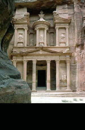
The Treasury (Al Khazna) of Petra of Jordan
 The Treasury is said to be one of the best tourist destinations not only in Jordan but in the World. With massive facades that have been carved entirely out of the existing red sandstone, Petra’s magnificent temples and tombs are like no other religious buildings in the world, and the surrounding rugged landscape dotted with historical sites are a hiker’s paradise.
Although the surroundings of the place are made of rocks, the Nabataeans provided their city with great tunnel constructions and water chambers.
For many people, Jordan begins and ends with the magical ancient Nabataean city of Petra. And it’s really true, Petra is without doubt one of the Middle East’s most spectacular, unmissable sights, battling it out with Machu Picchu of Peru or Angkor Wat for the title of the world’s most dramatic ‘lost city’. Visit the place if you find time. Without a tour in Petra will not be complete.
Protected of the wind for its location, the erosion have not work so much over its facade. Columns, figures, conical roof, all worked with great maestro. You can easily see the steps at the wall going up to the top that were used to reach the top and do the work, from the top to down.
The best moment when you get to the end of the Siq and you get the first view of the Treasury.
The best moment when you get to the end of the Siq and you get the first view of the Treasury.
Did you know? That Petra is now again one of the New Wonders of The World, voted by millions of voters around the world to represent global heritage throughout the history. Today, Petra and the surroundings are considered as Top Tourist Destinations of Jordan, no wonder why people keep on coming back here.
Matenadaran of Armenia
 Matenadaran is very famous Institute of Ancient Manuscripts built by architect Mark Grigoryan in 1957.
Everyone who visits Yerevan also enjoys the place of the institute because it is one of the city’s major landmarks and is considered as one of the Best Tourist Destinations of the country.
Standing in front of the entrance are sculptures of the great thinkers, scientists and cultural figures of ancient times Toros Roslin (13th century), Grigor Tatevtsi (15th century), Anani Shirakatsi (7th century), Movses Khorenatsi (5th century), Mkhitar Gosh (12th century) and Frik (14th century).
The meaning of Matenadaran in old Armenian means “depository of manuscripts” and “library”. The Matenadarin is a large research centre for the study and for the protection of manuscripts. The Medieval Armenia and People in ancient took great care of their manuscripts as they played an significant role in the people’s struggle against spiritual enslavement and assimilation.
All the large monasteries and universities had special scriptoria where master calligraphers made copies of books by Armenian scholars and writers and the works of foreign authors were translated into Armenian.
The oldest parchment book in the depository is said to be the Gospel of St. Lazarus which is written in 887 A.D., although there are earlier specimens which are incomplete and dated from the 5th-8th centuries. The oldest document on paper refers to 981 A.D. Visitors, of whom there are more than 50,000 a year, can see the best specimens of beautifully illustrated hand-written books displayed in the exhibition hall on the second floor.vThe largest in the world (34 kilograms) Armenian manuscript is displayed on a separate stand. It took seven hundred calf skins to make it. Next to it is a tiny book measurinl 3×4 centimetres and weighing a mere 12 grams.
Did you know? That tens of thousands of Armenian manuscripts have been destroyed in the countless wars and invasions that ravaged the country and only 25,000 manuscript volumes have been preserved . Of these there are more than 10,000 folios and also 2,500 fragments in Matenadaran. The rest are to be found in museums and libraries all over the world, mainly in Venice, Jerusalem, Vienna, Beirut, Paris and London.
Al Fateh Mosque of Bahrain
 Al Fateh Mosque was named after Ahmed Al Fateh, the conqueror of Bahrain. One of the more interesting architectural and cultural sites in Bahrain is the Al Fateh Grand Mosque. Like much of the buildings in Manama, it is a relatively new building.
Ahmed Al Fateh was the leader of the Al Khalifa tribe which took control of Bahrain from the Persians in 1783. The Al Khalifas remain the ruling family of the Kingdom of Bahrain.
The Mosque is oriented towards Mecca. There is a Qiblah, or niche in the wall, that shows the direction towards Mecca. All face the Qilbah during prayer. Women are not allowed on the main floor during prayers. They are to be separated during prayer, and in the Al Fateh, women stay in the balcony during prayer time. Besides the regular prayers, the mosque is also used as a meditation area for muslims, and as a place to teach the meanings of the Quran, especially to the young.
The mosque also includes an Islamic Center, which includes a library full of islamic literature translated into a number of different languages; free copies of certain publications are also available, such as foreign translations of the Quran, the basics of Islam, and so on.
Guests are very welcome to visit the mosque, and tours (available in a number of different languages) inside can be arranged free of charge. You do not need to schedule an appointment, but calling before to plan is preferable, especially if you are with a large group. Timings are from 9:00am-4:00pm, Saturday through Thursday (except during prayer time). Guests are requested to dress moderately; women will be provided with cloaks and head-scarves before entering.
Did you know? That the Al Fateh Mosque is the World’s Largest fiberglass dome and can accommodate up to 7,000 worshipers at a time which held five times a day.
Siargao Island of the Philippines
 Siargao Island is a hidden tropical jewel of the Pacific that hosts one of the most beautiful beaches in the world and home of wave surfing and the famous CLOUD 9, the latest sport and tourist attraction to take the country by storm.
Siargao is considered as the Surfing Capital of the Philippines. The best known surfing break now with a world reputation of being in the top Surfing Waves in the world, is nick-named “Cloud Nine”. But there are literally scores of breaks down this coast, and every time a surfing expedition is mounted in the area, more new breaks are being discovered.
The east coast is relatively straight with one deep inlet-Port Pilar with a coastline marked by a succession of reefs, small points and white sandy beaches. There are similar neighboring islands and islets with similar landforms. The reefs and points are excellent for picking up any swell that comes along turning into clean, fast waves. The Island’s Pacific-facing reefs are situated on the edge of the Philippine Trench, and the extremely deep offshore waters guarantee the ocean swells have undiluted power when they encounter the many coral and rock reefs, giving Siargao excellent surfing conditions, particularly during the southwest “habagat” monsoon from August to November, when the prevailing wind is offshore. The area is pure tropics with the plenty activities including snorkeling, island hopping, waterfalls, swimming holes and of course awesome waves and friendly locals.
This right-breaking reef wave is the site of the annual Siargao Cup, a domestic and international surfing competition sponsored by the provincial government of Surigao del Norte. The wave was discovered by travelling surfers in the late 1980’s, and named and made well-known by American photographer John S Callahan, who published the first major feature on Siargao Island in the US based SURFER Magazine in March 1993, and hundreds of photos in many other books and magazines since. Callahan has returned to the island many times since his first discovery in 1992, and his efforts to photograph and publish surfing related and general location material from Siargao islandin books and magazines around the world has put the island on the international map and drawn thousands of surfers and tourists to Siargao island.
Did you know? That Siargao is a tear-drop shaped island situated 800 kilometers southeast of Manila in the province of Surigao del Norte. It has a land mass of about 437 kilometers. And Siargao Island, faces the Pacific Ocean and the Philippine Deep, the second deepest water in the world, at more than 11 km below sea level.
Band-e Amir of Afghanistan
 Band-e Amir glittering lakes of Band-e Amir rank as Afghanistan’s most astounding natural sight, hidden in the Koh-e Baba at an altitude of 2900m. A series of six linked lakes, their deep blue waters sparkle like otherworldly jewels against the dusty mountains that surround them.
Approaching Band-e Amir, the first hint you have of their striking qualities is a bright flash of lapis lazuli as the largest lake, Band-e Zulfiqar appears briefly to your right. Soon after, the road starts to descend from a plateau immediately above the flat mirror of Band-e Haibat. Its deep blue waters and white dams fringed with vegetation are a rude shock when set against the cream and pink mountains – a sight to draw breath from even the most jaded travellers.
The lakes’ high mineral content gives them their colour, and in the case of the most accessible lake, Band-e Haibat (the suitably named Dam of Awe), these minerals have been deposited along its shore to produce a huge curtain wall over 12m high, streaked with sulphur and containing its waters high above ‘ground’ level. It’s a weird and stupendous sight, and it’s not surprising that locals should far prefer a mythic, rather than geological, explanation for the lakes’ formation.
The lakes are reputed to contain great healing powers and pilgrims still visit to take the waters. Arriving at the floor of the valley, vehicles stop a five-minute walk away from the dam walls, near a cluster of chaikhanas and kiosks.
Manafaru of Maldives
 The Maldives, a strand of coral atolls south of India, is just about the most tenuous country on Earth. No patch of land in the island chain, where the population has risen from 200,000 to 400,000 in the last 25 years, is more than six feet or so above sea level. Even modest projections for a rise in sea level from global warming would increase flooding from storm surges. A higher rise could render hundreds of islands uninhabitable.
The pearls of the Indian Ocean, as it is popularly known, are situated in the South West of Sri Lanka, on the equator. The numerous coral reef islands, 1,190 in total , form an archipelago of 26 major atolls ( groups of neighbouring coral islands). The country stretches 820 km north to south and 120 km east to west. Out of the incredibly large number of islands only 200 islands are inhabited, with 44 islands adapted as exclusive resort islands. The climate is generally warm and humid. Sun shines all year through with average temperature around 29 – 32 degrees Celsius.
Resorts in the Maldives woo tourists with promises of ‘the last paradise on earth’. If your idea of paradise is a pristine, tranquil tropical island with swaying palm trees, pure white beaches and brilliant turquoise lagoons, then the Maldives won’t disappoint. This group of 1190 coral islands is also a major destination for scuba divers, who come for the fabulous reefs and the wealth of marine life; however, this is not a place for low budget backpackers or amateur anthropologists who want to travel independently and live as the locals do.
Did you know? That Maldives archipelago has been nominated for the New 7 Wonders of Nature campaign. This campaign is a process in which seven natural wonders of the world are chosen by people through a global poll which will be declared in the year 2011. The campaign is being organized by the Swiss based New7Wonders Foundation after their success in organizing the New Seven Wonders of the World in 2007.
Baguio City of the Philippines
 The name Baguio conjures, for both the international and domestic traveler, a highland retreat in the Grand Cordillera in Northern Luzon, with pine trees, crisp cold breezes and low verdant knolls and hillocks. Through the numerous decades Baguio has morphed from what was once a grassy marshland into one of the cleanest and greenest, most highly urbanized cities in the country. It has made its mark as a premiere tourist destination in the Northern part of the Philippines with its cool climate, foggy hills, panoramic views and lovely flowers. Being the ideal convergence zone of neighboring highland places, Baguio is the melting pot of different peoples and cultures and has boosted its ability to provide a center for education for its neighbors.
Few history of Baguio: The arrival of the Americans in the early 1900s spurred development in the City. The American Governor Luke E. Wright commissioned Architect Daniel H. Burnham, a prominent Urban Planner to develop a plan for a health resort where the American soldiers and civilian employees could find respite from the sweltering lowland heat. This plan, better known as the Burnham Plan greatly altered the original mountain settlement and provided the first physical framework plan for the City. It paved the way for rapid physical development, the undertones of which are still visible up this date.
The physical framework as embodied in the Burnham Plan integrates a road and park system into one. It envisioned evolving in a compact garden city for 25,000 to 30,000 people. Supporting this development plan was the enactment of a charter approved on September 1,1909 that provided administrative as well as managerial autonomy for the city. Soon after the city’s charter was enacted, scenic Kennon Road was opened to vehicular traffic. This triggered the mining boom in surrounding areas in the early to mid 1930’s. Baguio City was the service and operations center for the mining industry, and hence a direct beneficiary of the economic growth. The events of the Second World War stalled all development, leaving the city in total devastation. Fast placed development however ensued following the war years. Such development trends transformed the city into what it is today, a premier urban center north of Manila, performing a municipality of roles, as an educational, trade, tourism and administrative center
Baguio City is approximately 250 kilometers north of Manila, situated in the Province of Benguet. The area of the city is 49 square kilometers enclosed in the perimeter of 30 kilometers. The developed portion of the city corresponds to the plateau that rises to an elevation of 1,400 meters. Most of it lies in the northern half of the city. The City is landlocked within the province of Benguet, thus bounding it on all sides by its different municipalities; on the North by the capital town of La Trinidad, on the East by Itogon and to the South and West by Tuba. With City Hall as reference point, it extends 8.2 kilometers from East to West and 7.2 kilometers from North to South. It has a perimeter of 30.98 kilometers. The City has twenty administrative districts among which its barangays are divided.
The City’s main attraction is still its natural bounties of cool climate, panoramic vistas, its pine forests and generally clean environs. Today, it still boasts of 5 forest reserves with a total area of 434.77 hectares. Three of these areas are watersheds that serve as sources of the City’s water supply.
Did you know? That Baguio is 8 degrees cooler on the average than any place in lowlands. When Manila sweats at 35 degrees centigrade or above, Baguio seldom exceeds 26 degrees centigrade at its warmest. Baguio is very wet during the Philippine rainy season, which is from June to October.
Lotte World of Seoul of South Korea
 Lotte World is like a small city with an amusement park, folk museum, sports center (including a skating rink and pool/water slide park), shopping center, and hotel. Most facilities are indoors, so they can be enjoyed throughout the year. The central area is open, so that several levels of people can watch the other people ice skating, enjoying the rides, eating, and shopping.
Lotte bills its World Adventure amusement park as the world’s largest indoor theme park. Opened in 1989, it was designed by some of the world’s most prestigious amusement park designers. The park has rides for everyone in the family, ranging from tranquil tram rides to exhilarating roller coasters. In addition to rides, the park has several shows each day and costumed characters that roam around. Operating hours: 9: 30 a.m. to 11:00 p.m.
Alongside Disney parks in the US and Japan, it is also one of the world’s favorites. By June 1999, Lotte World had attracted more than 50 million visitors, and by January 2005, this had grown to over 90 million. Also in 2005, Forbes Magazine ranked Lotte World as one of the World’s Top 10 Theme Parks. Much more than an amusement park, Lotte World also includes a department store, hotel, duty-free shops, superstores and a sports center, making it a living resort. A city within a city, where visitors can enjoy fun and adventure, be well looked after, and undertake many leisure activities, including shopping, culture, ice skating, swimming and bowling, all in one place.
Lotte World is also known for having the best IT systems of any theme park in Korea, initiating a broad range of computerized systems covering all aspects of its business. Of all the above accomplishments, the entrance management system, launched in 2006 was the first theme park system to achieve ’speed gate, auto ticketing machines and boarding reservations.
Gangtok Waterfalls of India
 Gangtok Waterfalls
A favourite height with honeymooners, trekkers and holiday makers, Gangtok is Sikkim’s proud capital boasting of mesh of magical places that is bound to make your heart skip a beat.
Situated in Shivalik Hills of eastern Himalayas, Gangtok is entry point to the East Sikkim and also to some northern parts of Sikkim. A Buddhist city, gompas, orchids, rhododendrons, stupas, tea gardens and grievous treks characterizes Gangtok’s geographical whereabouts.
With the organic beauty of the Gangtok Hills are juxtaposed the civic values and free-plastic zone in the city. Gangtok has an amazing civil sense where the smallest shop has a dustbin outside it. That is not just all. Know anything and everything about Gangtok at Gangtok Travel Guide.
Bang Saphan Beach of Thailand
 Bang Saphan is a sleepy beach town on the Gulf of Thailand, it can be reached from Bangkok, 380km away, in approximately 5 hours by road. There are actually two Bangsaphan’s; Bangsaphan Noi and Bangsaphan Yai (meaning big and small when translated from Thai). We will focus on the larger since not a lot happens in the smaller.
There are several local attractions including Koh Talu where day trips are popular. We also have a detailed accommodation guide listing Bangsaphan hotels, resorts, guesthouses and bungalows.
A Bangsaphan feeding guide highlights all the local and expat restaurants serving good food. There are a couple of friendly little beach bars in Bang Saphan that are also included. A great way to spend a relaxing afternoon.
Forbidden City of China
 Forbidden City was the Chinese imperial palace from the Ming Dynasty to the end of the Qing Dynasty. Located in the middle of Beijing, China, and now houses the Palace Museum. For almost five centuries, it served as the home of the Emperor and his household, as well as the ceremonial and political centre of Chinese government.
In the ancient time, the emperor claimed to be the son of the heaven and therefore their supreme power was conferred upon them from the heaven. Their residence on the earth was built as a replica of the Purple Palace where the God lived in the Heaven. Such divine place was certain forbidden for the ordinary people and it is why the Forbidden City is so called.
Did you know? That it was built from 1406 to 1420, covers an area of about 72 hectares with a total floor space of approximately 150, 000 square meters. It consists of 90 palaces and courtyards, 980 buildings and 8,704 rooms.
UNESCO listed Forbidden City as a world heritage site in 1987 and it has been listed as the largest collections of preserved ancient wooden strucctures in the world.
St. Basil’s Cathedral of Moscow
 St. Basil’s Cathedral is a well-known landmark in Moscow. The richly ornamented building was commissioned by Russian tsar Ivan IV, also known as Ivan the Terrible, to commemorate victories in battle and built between 1555 and 1679.
The chapels of Saint Basil’s are topped by colorful onion-shaped domes. Each dome is different in size and decoration. Officially known as the Cathedral of Saint Basil the Blessed, its original name was Cathedral of the Intercession of the Virgin.
The onion-domed building is polygonal in plan with fantastic bulbous towers and twisted turrets. Richly ornamented in color and gilt, Saint Basil’s Cathedral, with its ten chapels, aptly demonstrates the influence of the Byzantine artistic tradition that reached Russia from Constantinople (now İstanbul).
Did you know? That the construction of the building was begun in 1555 to celebrate the military conquests of Russian tsar Ivan IV Vasilyevich, known as Ivan the Terrible. Construction was completed in 1679.
Puerto Galera of the Philippines
 Puerto Galera (or port for galleons, if translated literally) is a small town on the northeast coast of the island of Mindoro in the Philippines. Though it is a quiet little town, it is a popular summer destination in the country. People come here from all over the country and the rest of the world for its wonderful beaches and fun water activities. Others also come in this beach for its nearby forests, waterfalls, and dive spots.
Puerto Galera has been attracting tourists for many years now. In truth, tourists flock to the neighboring towns of Sabang and White Beach and not to the actual Puerto Galera town. All of these towns, however, including the actual small town of Puerto Galera are all generally lumped together and referred to as Puerto Galera.
The little town has always been a trading haven even during the pre-Spanish era of its history. Evidence of this comes from artifacts from Thailand, Vietnam, and China dating way back into the 10th to 15th centuries. The Spanish took advantage of its natural harbor and used it for trade. The town soon became the government seat of the whole Mindoro Island. In December of 1927, Puerto Galera was turned into an independent municipality through a congressional act.
Water sports enthusiasts will find the place as a treat. Scuba diving is a big hit since the submarine ecosystem is fantastic. Dive shops in Puerto Galera offer beginner courses for those who want to take their first steps. Other water sports you can try include windsurfing, sailing, snorkeling, kayaking, and jet skiing.
Ancient City of Nessebar of Bulgaria
 Nessebar is situated on a rocky peninsula on the Black Sea, the more than 3,000-year-old site of Nessebar was originally a Thracian settlement (Menebria). It is a one of the most prominent tourist destinations and seaports on the Black Sea, in what has become a popular area with several large resorts-the largest, Sunny Beach, is situated immediately to the north of Nesebar.
The ancient part of the town is situated on a peninsula (previously an island) connected to the mainland by a narrow man-made isthmus, and it bears evidence of occupation by a variety of different civilisations over the course of its existence.
At the beginning of the 6th century BC, the city became a Greek colony. The city’s remains, which date mostly from the Hellenistic period, include the acropolis, a temple of Apollo, an agora and a wall from the Thracian fortifications.
Did you know? That in September 2005, only 10,194 have been claimed as the total number of population of Nessebar.
UNESCO listed Nessebar as world heritage site in 1983.
Temple of Preah Vihear of Cambodia
 The Temple of Preah Vihear, a unique architectural complex of a series of sanctuaries linked by a system of pavements and staircases on an 800 metre long axis, is an outstanding masterpiece of Khmer architecture, in terms of plan, decoration and relationship to the spectacular landscape environment.
The Temple is situated on the edge of a plateau that dominates the plain of Cambodia, the Temple of Preah Vihear is dedicated to Shiva. The Temple is composed of a series of sanctuaries linked by a system of pavements and staircases over an 800 metre long axis and dates back to the first half of the 11th century AD. Nevertheless, its complex history can be traced to the 9th century, when the hermitage was founded.
This site is particularly well preserved, mainly due to its remote location. The site is exceptional for the quality of its architecture, which is adapted to the natural environment and the religious function of the temple, as well as for the exceptional quality of its carved stone ornamentation.
Authenticity, in terms of the way the buildings and their materials express well the values of the property, has been established. The protective measures for the Temple, in terms of legal protection are adequate; the progress made in defining the parameters of the Management Plan needs to be consolidated into an approved, full Management Plan.
Sunway Lagoon of Malaysia
 Sunway Lagoon officially opened on April 29, 1993 by Prime Minister YAB Dato’ Seri Dr Mahathir Mohamad, Sunway Lagoon is Malaysia’s Premier Theme Park and has become the most visited tourist destination in the country.
Sunway Lagoon is strategically located in the township of Bandar Sunway in Petaling Jaya. It is accessible via a network of expressways (Federal Highway, Damansara-Puchong Expressway, New Pantai Express Way and KESAS Highway) and is a mere 15 minutes’ drive from Kuala Lumpur.The convenience is enhanced by the provision of ample parking facilities and public transportation. Taxis and bus services are aplenty. KTM Komuter trains stop at Subang Jaya Station, while Putra-LRT Spanning 80 acres, the Lagoon draws fun seekers from all over with its reputation as a fascinating land of fun and excitement.
Sunway Lagoon is separated into 3 major themed lands, each boasting their own exciting attractions. Find entertainment, adventure and excitement all in place. A place where you will bring back more than just memories.
Sunway Lagoon, being part of Malaysia’s first fully-integrated themed resort – Sunway Lagoon Resort, offers visitors the conveniece of a 5-star hotel, a grand shopping mall right next door and other ultra-modern facilities.
Senado Square of Macau
 Senado Square has always been the city centre. In the past, this was where the governors inspected military troops and the police force when they took up their posts. The warm pastel shades of the restored neo-classic buildings and distinct wave patterned mosaic tiled flooring create a Mediterranean atmosphere.
Marvellous colonial buildings surround the square which is popular with locals and tourists alike. Note the fountain and the mosaics adorning the ground as you stroll along, enjoying the day. By the way, it is a bad idea to buy at the antiques shops close to St. Paul’s because you will be paying through your nose by about 100 percent.

Senado Square is best accessed from Avenida de Almeida Ribeiro on Macau Peninsula. If you have further plans for Macau, visit the tourist information located on the left of the square.
Truly Macau is one of the most visited site in Asia because of the Old houses and infrastructures they have. One of the good thing about the destinations of Macau is that, some of it are not very far, you can just walk to reach the other destinations.
I would love to advice you to walk instead of riding the public transportation when visiting the destinations of Macau.
Disneyland of Hong Kong
Disneyland is said to be the best attraction of Hong Kong. Hong Kong Disneyland is located on Lantau Island, and is accessible via an array of convenient transportation options.

The Disneyland Hong Kong Resort originally opened with about 300 acres, four lands, 21 rides, and two hotels. The actual park debuted with about 100 acres. Construction of Disneyland Hong Kong Resort began in January 2003. Site preparation, land reclamation, initial layout of roads and infrastructure, and public park landscaping by the HKSAR Government preceded construction.
The Disneyland Hong Kong project was announced in 1999. Up to 5,000 workers were on the job at one time. Disneyland Hong Kong opened on September 12, 2005 at exactly 1 p.m., a date and time determined to be extremely lucky by a Chinese consultant. September 12 is a good date for the opening of a new business, according to a Chinese almanac that lists what is lucky and what is not for each day of the year.
 time. Disneyland Hong Kong opened on September 12, 2005 at exactly 1 p.m., a date and time determined to be extremely lucky by a Chinese consultant. September 12 is a good date for the opening of a new business, according to a Chinese almanac that lists what is lucky and what is not for each day of the year.
Did you know? That the Hong Kong Disneyland, is the smallest Disneyland in the World and the project cost $3.5 billion to construct, with the Hong Kong government paying much of the bill and the Walt Disney Company sporting a smaller percentage.
 with the Hong Kong government paying much of the bill and the Walt Disney Company sporting a smaller percentage.
NEW UPDATE: WARNING TO ALL TOURISTS!!!
To everyone planning to visit Hong Kong Disneyland, please be forewarned of the travel agencies you chose to book your trip. I purchased a tour package with PHILIPPINE EXPLORER TRAVEL AGENCY and the experience has been stressful. Philippine Explorer partnered with HOLIDAY WORLD TOURS LTD. to deliver the package to me upon my arrival in Hong Kong but I ended up with myself worrying for my Disneyland. I had to go to Disneyland and buy ticket by myself despite the fact that the tour package I bought from PHILIPPINE EXPLORER supposedly covers all the expenses.
Below is a video, depicting my cousin arguing with the tour guide (JAMES) who works for HOLIDAY WORLD TOURS LTD. Check out how rude he gets when we questioned why aren’t we included in the tour to Disneyland. The conversation ended up with James dropping us at the middle of the city all by ourselves.
If you encountered the same thing, do leave your comments and let the management of Holiday World Tours Ltd. know about your demands and concerns.
Temple of Heaven of China
 Temple of Heaven
The design of the Temple of Heaven complex, true to its sacred purpose, reflects the mystical cosmological laws believed to be central to the workings of the universe. Hence, complex numerological permutations operate within its design. For example, because the number nine was considered to be the most powerful digit, you will see that the slabs that form the Circular Altar have been lain in multiples of nine.
The Temple of Heaven is the most holy imperial temples in Beijing. For this is where the Emperor came every winter solstice to worship heaven and to solemnly pray for a good harvest. Since his rule was legitimised by a mandate from heaven, a bad harvest could be interpreted as his fall from heaven’s favour and threaten the stability of his reign. So it was not without a measure of self-interest that the Emperor fervently prayed for a very good crop.
In addition with the Confucianist revival during the Ming dynasty, the sacred harvest ceremony was combined with the Emperor’s worship of his ancestors. This embellishment was also, in effect, self-interested.
According to the Confucian pattern of social organization, just as the Emperor respected his ancestors, so a younger brother should respect an elder brother, a wife with her husband, a son with his father, and a nation’s subjects their ruler. Incorporating ancestor worship within the most solemn ceremony of the Imperial ritual calendar, indirectly reinforced the social philosophy that perpetuated the Emperor’s power.
Sentosa Island of Singapore
 Sentosa Island was once a fishing village known as Pulau Blakang Mati. It later became a British military fortress until 1967 and was handed back to the newly independent Singapore Government. In 1968, the Government decided to develop the island into a holiday resort for local visitors and tourists. The public was invited to suggest names for the island and “Sentosa” which means peace & tranquillity in Malay – was eventually chosen for the island resort.
Today, Sentosa is Singapore’s premier island resort getaway with multi-faceted appeal, teeming with events all year round. Just 15 minutes from the  city, it is a unique blend of leisure and recreational facilities including family attractions, sea sports, golf as well as hotel accommodation and retreats. Accessed by cable car, bus, taxi or car, the island is open for 24 hours a day, 365 days a year. Since the island’s inception in 1972, S$420 million in private investments and another $500 million from Government funding have gone into developing the island.
 city, it is a unique blend of leisure and recreational facilities including family attractions, sea sports, golf as well as hotel accommodation and retreats. Accessed by cable car, bus, taxi or car, the island is open for 24 hours a day, 365 days a year. Since the island’s inception in 1972, S$420 million in private investments and another $500 million from Government funding have gone into developing the island.
The Sentosa Island itself is already a destination however, there are many tourist spots to enjoy inside the island just like the Merlion Walk, the Underwater World, beach like the Siloso Beach which is human made and tourist spots to enjoy! There are many hotels available inside the island just link the Amara Sanctuary Hotel.
 Did you know? That a canopy of secondary rainforest covers 70 per cent of the 500-hectare island and is home to monitor lizards, monkeys, peacocks, parrots as well as other native fauna and flora. Sentosa has a 3.2-kilometre stretch of white sand beach, and is the only location in Singapore to offer beachfront accommodation and over 670 hotel rooms with full facilities.
Boracay Island of Philippines
 Boracay Island of the Philippines is considered to be one of the most beautiful beaches in the world.
Boracay Island of Philippines is known far and wide as an island paradise, Boracay has charmed vacationers with its powder white sand, crystal blue waters and purposely laid-back pace. Located at the norther tip of Panay province, Boracay is about three hours away from Manila.Sun worshippers from all over the world visit Boracay yearly, and some have even made it their second home. It is no wonder therefore, that French, German, Spanish and English can be heard spoken in the Island. The culinary fare is equally exciting featuring a wide range from Thai and Austrian to Belgian and Filipino. Numerous water sport facilities, including dive shops are on hand as well as a sprinkling of bars and discos. Most visitors, however prefer to sit back and enjoy the sun.
The most famous part of Boracay is its 4 kilometer stretch of the finest, most pristine white sand beaches, White Beach, where the color of the sea blends with that of the sky during the day and the white sands glimmer at night. So awesome is the Island that the best descriptions cannot give justice to Boracay’s natural beauty. Boracay’s attractions do not stop at its natural beauty. A wide range of accommodation serving every visitor’s lifestyles is available on the Island.
Did you know? That according to Yahoo! Travel dated June 5,2007 of 2007 “World’s Best Beaches”, Boracay Island have been listed as the 7th Best Beach of the World.Yasawa Island of Fiji
 Yasawa Island Resort is one of the most luxurious hotels.blogspot.com/”target=”_blank”title=”Accommodations” >accommodations you will discover in Fiji. There are 18 thatched bures cuddled upon a beautiful white powdery beach at this Yasawa Island Resort. All the bures have wonderful large decks, large bathrooms, and comfy king sized beds. Not only will you enjoy the comfort and quiet of the Yasawa Island Resort but also you will love the homemade cookies and awesome half shell clam basin. Attractions and activities close by include mountain biking, snorkeling, and scuba diving.
Cruise ships consider Yasawa Island Fiji a must see as they leave Lautoka and stop off at the white sandy shores of Yasawa Fiji. The most popular islands in the Yasawa Island Fiji cluster for visitors are Yasawa, Nacula, Tavewa, Nanuya Lailai, Matacawa Levu, Naviti, and Waya.
Did you know? That Yasawa Island of Fiji is the most beautiful and most South Pacific Islands in all of Fiji. Both versions of Blue Lagoon were filmed in this tropical and breath taking Yasawa Fiji.
Talofofo Falls of Guam
 Talofofo Falls is a waterfall located in the southern section of Guam. Talofofo Falls is located in Talofofo Falls Park, and is one of the major tourist attractions in Guam. The beautiful falls offer a cool reprise from the hot beach, and travelers love the freshwater Talofofo Falls and surrounding Talofofo Falls Park as a day trip destination from anywhere on the island. A whole host of activities are within easy reach from Talofofo Falls and Talofofo Falls Park.
Another of the most popular tourist attractions in Guam are the golf courses located near Talofofo Falls. Many travelers who love to golf plan to visit both the falls and the main golf course to round out the day. If you are hoping to make such a plan, you will want to be sure and schedule a tee time in advance. Although walk-ons are available at times, you will do best to plan a time in advance. There are fees to play the course.
One of the most exciting things to do at the falls happens right away. To get down to Talofofo Falls, guests will need to take a gondola ride. The gondola offers views of the forest as you travel above the trees and swoop down toward the falls. The falls themselves open into a gentle freshwater pool which is ideal for swimming, swinging from a rope and lying out in the sun.
Borobudur Temple of Indonesia
 Borobudur Temple is one of the most prestigious historical properties that can be found in Indonesia. The existence of the Borobudur was discovered by General Governor Sir Thomas Raffles around 800 A. D., after being buried for a long time following the eruption of Merapi Volcano. The remarkable Borobudur temple complex is a monument to the Lord Buddha. Constructed in the 9th century, Borobudur Indonesia has long since been a place for religious pilgrimage.
Annually, the Borobudur Indonesia temple becomes the centre of the Vesak festival. In commemoration of the birth, death and attainment of wisdom of Siddhartha Gautama, founder of the Buddhist religion, Borobudur becomes the epicenter of ceremony. The Vesak festival is marked by a procession of devotees walking between the Buddhist temples of Mendut and Pawon, ending finally at the Borobudur temple.
Borobudur is derived from “bara” / “vihara” that means “Temple” and “budur” or “buduhur” that means “above” or “Hill”.
Did you know? That this monument has a height of 34.5 meters and comprises of 10 layers., which the lower six are square and the upper three layers are circular. Reliefs in the wall are counted about 1460, while the Buddha statues are about 504 and 72 stuapas.
UNESCO listed the Borobudur as world heritage site.
Zao National Park of Japan
 Zao National Park on the Yamagata-Miyagi prefecture border, is a mountain park centering around the Zao mountain range. You can enjoy the beauty of the nature when you visit the mysterious Okama crater lake which is also called
 Goshiki-numa (five-color marsh) since its water color changes several times in a day, and Zao Shizen-shokubutsu-en or (botanical gardens), a treasure house of alpine plants. Aboard the rope way car, you can get a bird’s eye view of the whole of the Yamagata Basin. You can also enjoy a night view and a starry sky from the lodge or inns.
Did you know? That there are 28 National Parks in Japan . While about two thirds of the land area in Japan is composed of forested areas and roughly 80% of the terrain is mountainous, it is no wonder that there are many beautiful National Parks with diverse geographic features located all over Japan . National Park areas cover 5.4% of Japan’s total land area. But Zao National Park is considered to be one of the best Park because of its stunning beauty.
Phi Phi Island of Thailand
 Phi Phi The name derived from Malay word and the original was Pulao Pi ah Pi, where in pulao is the Malay word for island, and pi, pronounced with only a half p sound, was very close in pronunciation to the English word be. The name refers to the mangrove wood found there.
Did you know? Six islands are in the group; Phi Phi Don, Phi Phi Ley, Biddah Nok, Biddah Nai, Yung, and Pai (Bamboo Island) with a total area of about 35 square kilometers. They were incorporated into the national park in 1983. Some of the interesting places to visit include.
Phi Phi islands consists of 2 islands, Phi Phi Don, the larger one of the two with an profusion of fine beaches and lodgings to suit all needs. The more geographically dramatic, Phi Phi Ley, with its cliffs, natural caves and water-filled canyon offers the tourists exciting and outdoor pursuits. Both islands are in Krabi province and are part of Nopparat Thara Beach/Phi Phi National Marine Park, Just a short 42 kilometers from from Phuket, will move you to the tropical paradise and famous islands of Phi Phi Island.
A very fine, white sandy beaches and tremendous rock formations rising from the vivid turquoise waters that surround the islands will instantly confirm you’ve arrived in paradise.
Truly Phi Phi island is one of the best beaches in the world.
Old City of Acre of Israel
 Acre is a historic walled port-city with continuous settlement from the Phoenician period.
The present city is characteristic of a fortified town dating from the Ottoman of about 18th and 19th centuries, with typical urban components such as the mosques, citadel, khans and baths.
The remains of the Crusader town, dating from 1104 to 1291, lie almost intact, both above and below today’s street level, providing an exceptional picture of the layout and structures of the capital of the medieval Crusader kingdom of Jerusalem.
UNESCO listed Old City of Acre as world heritage Site.
Taj Mahal of India
 Taj Mahal is considered to be the most beautiful monument ever built by the Mughals, the Muslim rulers of India. Taj mahal is entirely built of white marble. Its stunning beauty is beyond adequate description, especially during dawn and sunset.
Emperor Shah Jahan (died 1666 C.E), Muslim, the person behind the Taj Mahal. He built it in memory of his dearest wife and queen Mumtaz Mahal at Agra, India.
.
Did you know? That Taj Mahal was constructed over a period of 22years, employing 20,000 workers. It was completed in 1648 C.E. at a cost of 32 million Rupees. The Taj Mahal stands on a raised, square platform (186 x 186 feet) with its four corners truncated, forming an unequal octagon. Its central dome is fifty-eight feet in diameter and rises to a height of 213 feet. It is flanked by four subsidiary domed chambers. The four graceful, slender minarets are 162.5 feet each.
.
UNESCO listed the Taj Mahal as one of the Eight Wonders of the World.
Rice Terraces of the Philippine Cordilleras
 The Ifugao Rice Terraces epitomize the absolute mixture of the physical, socio-cultural, economic, religious, and political environment. Indeed, it is a living cultural landscape of unparalleled beauty. The Ifugao Rice Terraces are the priceless contribution of Philippine ancestors to humanity.
The terraces illustrate a persistence of cultural traditions and remarkable continuity and endurance, since archaeological evidence reveals that this technique has been in use in the region for 2000 years virtually unchanged. They offer many lessons for application in similar environments elsewhere.
Did you know? That the Rice Terraces was built 2000 years ago and passed on from generation to generation, the Ifugao Rice Terraces represent an enduring illustration of an ancient civilization that surpassed various challenges and setbacks posed by modernization.
Nowadays, the Ifugao Rice Terraces is said to be in danger due to the growth of population, and some of the so called next generation are leaving the place to work in City, like Manila, the Capital of the Philippines.
UNESCO listed the Ifugao Rice Terraces as world heritage site.
Golden Temple of Dambulla of Sri Lanka
 Golden Temple of Dambulla also known as Dambulla Cave Temple is a temple in central of Sri Lanka.
It is said that the cave had been occupied long before the arrival of Buddhism to Sri Lanka, with the oldest serious dating back around 700BC.
.
Located twelve (12) miles away form the site of Sigiriya, another Buddhist world heritage site.
.
The Cave of the Great Kings is the largest of the caves in the Golden Temple of Dambulla, containing forty statues representing the Lord of Buddha sitting, and another sixteen of the Lord Buddha standing.
.
Did you know? That the Golden Temple of Dambulla contains of more that a 150 statues of Lord Buddha, Kings and related deities and thousands of paintings of Buddha.
.
A sacred pilgrimage site for 22 centuries, this cave monastery, with its five sanctuaries, is the largest, best-preserved cave-temple complex in Sri Lanka. The Buddhist mural paintings (covering an area of 2,100 m2) are of particular importance, as are the 157 statues.
.
UNESCO listed the Golden Temple of Dambulla as world heritage site.
Historic Town of Vigan of Philippines
 Vigan is located in the north of the island of Luzon. The history began as colonial port under Spanish rule in 1574.
Did you know? That Eighty Percent (80%) of population of Vigan is of mixed Chinese and Filipino origin. And Vigan was the only 16th century colonial town in the Philippines to survive. Family of General from the Japanese Imperial Army occupied the town during the World War II. the general and his family took up residence in a typical Vigan-style home.The General’s wife is a Filipina.
It was a great experience I had here in Vigan. If you visit Vigan, I would love to recommend you to try the “Empanada”, a delicious snack similar to the Mexican Taco, of sauted cabbage or papaya with egg and Vigan Longganiza stuffed in crispy shell made of ground rice.
UNESCO listed Vigan as a world heritage site.
Minaret of Jam of Afghanistan

Minaret of Jam is one of the famous monuments of Afghanistan that can be found in the valley of Ghor province. Beside the Minaret, is the Hari Rud river that flows rapidly and is surrounded by barren mountains. It’s very hard to reach this monument, because you can only be negotiated by a sports utility vehicle or a jeep.
.
The Minaret of Jam has been discovered in 1957 by an expedition led by Ahmad Ali Kohzad, the president of the Afghan Historical Society and Andre Maricq, a french archeologist.
.
The 65m-tall Minaret of Jam is a graceful, soaring structure, dating back to the 12th century. Covered in elaborate brickwork with a blue tile inscription at the top, it is noteworthy for the quality of its architecture and decoration, which represent the culmination of an architectural and artistic tradition in this region. The impact is heightened by its dramatic setting, a deep river valley between towering mountains in the heart of the Ghur province.
.
UNESCO listed the Minaret of Jam as a world heritage site.
Great Wall of China
 The Great Wall of China is a Chinese fortification built from the 3rd century BC until the beginning of the 17th century, in order to protect the various dynasties from raids by Hunnic, Mongol, Turkic and other nomadic tribes coming from areas in modern-day Mongolia and Manchuria.
 The Great Wall of China is a Chinese fortification built from the 3rd century BC until the beginning of the 17th century, in order to protect the various dynasties from raids by Hunnic, Mongol, Turkic and other nomadic tribes coming from areas in modern-day Mongolia and Manchuria.
In 1987, “Great Wall” had been listed as one of the world’s heritage site by the UNESCO.
.
The Great Wall is considered to be the world’s longest man-made infrastructure, stretching over a formidable 6,352 kilometer, from Shanghai Pass on the Bohai Sea in the east, at the limit between “China proper” and Manchuria (Northeast China), to Lop Nur in the southeastern portion of Xinjiang Uygur Autonomous Region. Along most of its arc, it roughly delineates the border between North China and Inner Mongolia.
While some portions near tourist centers have been preserved and even reconstructed, in many locations the Wall is in disrepair, serving as a playground for some villages and a source of stones to rebuild houses and roads. Sections of the Wall are also victims of graffiti and vandalism. Parts have been destroyed because the Wall is in the way of construction sites. Intact or repaired portions of the Wall near developed tourist areas are often plagued with hawkers of tourist kitsch. The Wall was made a UNESCO World Heritage Site in 1987. Mao Zedong had a saying: “You’re not a real man if you haven’t climbed the Great Wall”.
http://www.globetourguide.com